About Me

My photo
Way back in time before the onset of adulthood I enjoyed countless days heading into the hills of Yorkshire with nothing more than a squashed sandwich & youthful sense for adventure! Despite long past youthful and work commitments keeping me in the city, the sense of adventure and love for the outdoors never left me. After digging my boots out and returning to the hills I attended a number of courses to improve my hill knowledge and skill base, during one of these courses it was suggested I join the Mountain Leader Training scheme and was delighted go on to gain the MOUNTAIN LEADER Award in April 2012. As well as spending time on the hills and mountains of the UK I have also enjoyed trips to the Nepalese Himalaya, Swiss & French Alps, Mallorca’s Tramuntana, Andorran & French Pyrenees, Morocco’s High Atlas, Tanzania’s Mt Meru & Kilimanjaro, Argentinian & Chilean Patagonia and winter expeditions to Norway’s Hardangervidda. Since gaining the ML I have also gained the SINGLE PITCH AWARD, INTERNATIONAL MOUNTAIN LEADER AWARD and the WINTER MOUNTAIN LEADER AWARD. I am now enjoying working in a freelance role whilst trying to get out climbing as much as possible.
Powered By Blogger

Friday, 12 April 2013

British Summer Time - Winter Routes!

 As the clocks changed to signal the official end of British Winter Time it seems nobody remembered to tell the Jet Stream!
 With the Jet Stream having a 'kink' in it which meant it was racing across the skies above Southern Spain, cold air from Northern Europe and strong Easterly winds were the major influence on the weather over the British Isles - bad news for most, but not if your wanting to get out on the mountains for some bonus winter routes!
April in the Lake District from Blencathra.
April Fools Day in the Lake District. - Deciding I could not miss the opportunity to get out on the hills whilst still under winter conditions, I set off at 05:30am for an early journey to the Lake District.
 Arriving in the Lake District in cold, bright but breezy conditions I aimed to ascend to the summit of Blencathra via Hallsfell Top Ridge, which would give me a Grade I winter climb, and descend by the iconic Sharp Edge which would give me a Grade II climb for my Winter Mountain Leader log book. I would also have the option of descending via alternative routes should Sharp Edge look a bit 'dodgy'!
Hallsfell Top and Blencathra in above the snow line.
  Carrying all the winter extra's - ice axe, crampons, rope, slings, carabiner's and spare clothing I made my way up Hallsfell and into the snowline on Hallsfell Top ridge where I was exposed to the biting Easterly winds for the first time on the route.
 On along the ridge I took out my ice axe and put on my crampons before the path became too exposed and a slip would of been fairly terminal. Rime ice and small cornice's were evidence of the strong winds and freezing temperatures of the previous week or so.
Looking back down Hallsfell Top.

 Reaching the summit of Blencathra the wind became much stronger with buffeting gusts of approx up to 50mph which started to cast doubt in my mind of crossing Sharp Edge. Walking across to the top of the ridge I was forced to put on my ski goggles as my eyes were streaming in the bitingly cold winds so I could assess the conditions as again a slip could be fairly terminal, not least because of the freezing temperatures meaning an immobilising injury could lead quickly into hypothermia!
 After taking a look at the route across Sharp Edge I felt it was do-able with some care, the main problem would be the winds though these were blowing along the ridge rather than at an angle across the ridge.
Sharp Edge dropping from left to right.

 Making my way down on to the ridge I escaped the worst of the winds and began across the sharp rock formation of the arete which gives the ridge its name. I noticed that 2 groups had set off from the opposite side of the ridge and had decided to turn back which was a little unnerving for a moment but I was committed to the route and continued to cross carefully.
the 'sharp' bit of Sharp Edge.
Sharp Edge in all its winter glory!

 As I reached the 3/4 point of the ridge I found the winds extremely strong and had to choose my moments to move on, this is probably what caused the other groups to turn back.
 I thoroughly enjoyed both ridges and the conditions made them all the more enjoyable by making them more challenging!

Snowdonia in the Snow- Following the my solo trip to the Lake District I made my way to Snowdonia to meet up with Brett Savage (Savage Adventures coming shortly!) to join him on a couple of winter routes in the Glyders.
 Wednesday we decided to head up Glyder Fach by following Bristly Ridge to the summit (Grade II Winter) and descending by Y Gribbin (Grade I Winter). Making our way from Lyn Ogwen we were straight into the snow which steadily got deeper as we made our way up to Lyn Bochlwyd.
Snow sculpture en route to Bristly Ridge.

 We made our way up the steeply rising broken boulders which form Bristly Ridge steadily as the climb was covered in soft snow and patches of ice and quickly gained height.
Brett gets the 'man leg' out!
 As the ridge rises there are sections which are very exposed with some sections of step overs which need care especially when under winter conditions.
More 'man leg' from the Savage, with Tryfan in the background.
"Yes Brett, the sweet shop is down there!"

 After reaching the top of Bristly Ridge we made our way to the summit of Glyder Fach and had lunch at the Cantilever Stone (photo's unavailable as Brett hasn't released them!!). We then made our way over to Y Gribbin which we descended back to the car park.

 It is worth mentioning that whilst leaving the summit we came across a group making their way up with a guide(?), non of the group had crampons or ice axes and one mentioned that they wished they did! I don't think its just personal preference, the mountains in winter are a serious undertaking and it always tends to be more difficult to get down than up when gravity is trying to speed up your descent!!

Thursday we headed back into the Ogwen Valley and past Lyn Idwal on our way to Cwn Cneifion where we had seen a climb in the North Wales Winter Climbing guide book by Simon Panton and Mark 'Baggy' Richards. A more strenuous walk in than we had origionally thought(!) we steadily made our way to Clogwyn Du where we planned to ascend Glder Fawr by climbing up Hidden Gully (Winter Grade II).
The walk in!
Brett leads the way on Hidden Gully.
  After the walk in the climb was all too short but still exciting in places in the conditions. Exposed to the strong cold winds on leaving the climb we walked to the summit point of Glyder Fawr (no cheating from us boys!) before making our way to the descent.

Looking down the Ogwen Valley.
 Back climbing down the descent I was regretting not putting on my as goggles as the wind whipped up the back of the Cwm blowing loose snow into our faces. It was then mainly a bum slide and some ice axe arrest practice all the way down to Lyn Idwal.

All in all 3 Winter Routes including 5 graded winter climbs for myself so time well spent!!

N.B No photo's were available from Brett (lazy boy) Savage for this blog!!!


Wednesday, 6 March 2013

Snow Holes, Sheds & School Dinner in the Cairngorms - February 2013

With much of the UK enjoying clear still skies due to a lengthy period of high pressure and after consulting the avalanche forecast (Scottish Avalanche Information Service), I decided it was too good an opportunity to miss and headed for the mountains of the Cairngorm National Park in the Eastern Scottish Highlands for a 3 day mini expedition & 3 valuable Winter Mountain Leader log book days!

 Making the 6.5hr journey North I arrived in Braemar late Sunday night (too late to find any food available!) and stayed overnight in a local hotel with the idea of being refreshed for an early start the following morning. Unfortunately due to a 'slight' failure in the body clock department things didn't go exactly as planned so it was after a hurried breakfast that I drove to the Linn of Dee car park on the Mar Lodge Estate to begin my 3 day stroll.

 Day 1 - Leaving the 'Linn of Dee' car park it took me around an hour to reach 'Derry Lodge' following Lui Water as it made its way through the snow covered landscape.  From Derry Lodge I took a route that led North West and started ascending through the tree line until I was making my way up the hard neve on the flanks of 'Carn Crom'. From 'Carn Crom' I carried on ascending over 'Little Cairngorm' and to the summit of 'Derry Cairngorm (1155m). Progress hadn't been record breaking in the warmth of the bright winter sun with its snow glare, and with a full 3 day pack on my back!


 As I made my way towards 'Ben Macdui' I noticed a snow bank which looked suitable to build a snow hole in. After deliberating weather to walk up to Ben Macdui then back down to shelter overnight at the 'Hutchinson Memorial Hut' and then back up to continue my route the next day I opted to put try put some skills I had gained on winter skills courses into practice and build myself a snow hole!
 Digging a shoulder width hole into the snow bank I removed snow until I could get the trunk of my body in the hole. At this point I started to dig out the snow parallel to the outside snow wall leaving around 150cm of snow. After digging a tunnel around 3ft long I took myself out of the hole and moved along the snow bank approx 6ft, here I repeated the process in the opposite direction until I had dug myself out a tunnel approx 6ft long and 3ft high. At this stage I shaped the walls and ceiling smooth to prevent water dripping from them and leveled the floor. Digging 12inch deep trenches at either entrance which would act as cold wells the snow hole was soon ready for me to put in my bivvy bag, roll mat & sleeping bag - cosy!
 I measured a temperature of 0C inside the snow hole through the night whereas the outside temperature had been forecast for 8C.
Digging into the snow bank.
2nd window/door.
Creating the tunnel.
Bivvy bag & kit in the snow hole.
Cosy apartment or the evening!
Day 2 - rising with the sun I had breakfast and packed up my kit and left the snow hole (which is available to rent for a short period?), I then made my way up to the summit of Ben Macdui (1308m) which is the second highest mountain in Great Britain. From a rime ice covered summit at 8am on a bright winters morning I was treated to 360 degree views over the East Highlands of Scotland as far as the eye could see. I could also see the peak of Cairn Gorm North East some 6km away which is where I was heading next.
Sunrise from my overnight 'apartment'.
 Making my way over the rolling plateau I passed by the satellite summits of 'Cairn Lochan''Stob Coire an t-Sneachda' before ascending to the summit of 'Cairn Gorm'(1245m) with its rime ice covered weather station. On the summit I met the first people I had seen since breakfast the previous day, a pair of snow boarders who informed me that the Ptarmigan restaurant of the Cairn Gorm mountain center was open and I headed there for lunch.
 During an 'expensive school dinner' at the Ptarmigan I set my route for the afternoon and decided I would head for the 'Fords of Avon' refuge rather than dig myself another snow hole as this would leave me a 5hour walk out before the long drive home rather than a lengthier and more tiring day.  I again crossed the summit of Cairn Gorm before making my way down thru Coire Raibert, following the path of the would be stream down to the banks of Loch Avon.
 The Loch was covered in snow and appeared well frozen but I resisted testing the strength of the ice and kept myself on the banks of the Loch as I made my way East towards the refuge which I reached around 15:30hrs.

 The 'Refuges' or 'Bothies' are small unmanned building or huts located in the remote mountainous areas of the UK. Mostly found in Scotland bothies provide a basic watertight and windproof shelter for anyone that may need them. Varying in size from small huts to 2 storey former cottages, some may have fireplaces & sleeping platforms whereas others may be nothing more than a large box, non offer bedding etc but all are free of charge and are left unlocked - Mountain Bothies UK

 After unpacking my sleeping kit and cooking equipment, I boiled water taken from the nearby 'burn' (Scottish name for stream or small river) and had my tea before retiring for the evening - at 17:30hrs!

Rime ice on Cairn Gorm weather station.
Snow covers the frozen surface of Loch Avon.
Refuge/Bothy at Fords of Avon.
Hotel it is not, shelter from the elements it is.
 Day 3 - Did you know the usually fairly silent (until your about to step on them as they hide disguised in the snow or heather, when they then fly out suddenly trying to make you sh*t yourself!) Ptarmigan and Black Grouse like to have a bit of a chat in the time just before dawn? I didn't but do now, and so it was before dawn that I awoke to gentle bird(!) song and made porridge for breakfast, packing my sleeping kit as I boiled water. The sun rising behind the horizon turned the surrounding mountain tops pink through to orange as I swept the floor of the bothy and removed any trace of having been there.
 Leaving the bothy heading South I took care to avoid the snow covered frozen surface of 'Dubh Lochan' & the 'burn' that feeds into them, which I could occasionally hear running from beneath the snow.  Dropping into Glen Derry I made my way over mixed patches of frozen ground, snow & ice which had been consolidated underfoot and delayed my decision to remove my crampons in the knowledge of tired legs and a rucksack that didn't seem to be getting any lighter!
 Joining the path on which I had set out 2 days earlier at 'Derry Lodge' I followed the track back to 'Linn of Dee' car park with a much reduced spring in my step but confident that making my way to the bothy rather than sheltering overnight in a snow hole had been the right choice!
Sun rise.
Glen Derry.
Summary. Over the 3 days I walked approx 42km and ascended over 1500m. There were alternative routes I could of taken but I felt 3 days & 2 nights spent out in winter conditions alone needed some respect as things could go wrong very quickly.
 My rucksack weighed around 16kg with the food, cooking equipment, sleeping equipment, snow shovel etc and the extra weight over a normal day pack made a noticeable difference to my pace and the effort needed when going up hill.
 I found the over nights no problem though weather conditions were still & dry which meant my clothes were dry.

 All in all it was a very worth while trip as it gave me 3 log book days towards the Winter Mountain Leader Training Scheme and a chance to put into practice some skills I had been previously taught. It also provided with me with 3 days in a stunning winter mountain environment.

Wildlife seen - Ptarmigan, Black Grouse, Arctic Hare.


Friday, 1 March 2013

Scafell Pike - My Mountain Nemesis?

Nem.e.sis
Something that a person cannot conquer, achieve etc.

 Found in in the Lake District National Park Scafell Pike is the highest mountain in England, with the summit standing at a height of 978 metres (3,209 ft) above sea level. It has a stony summit which can be reached via a number of routes, the most commonly used routes begin at Wasdale from the West and Seathwaite from the North East as these are the the common starting points used during the National 3 Peaks Challenge.

 It is at this point that I should confess Scafell Pike has never been my favourite mountain and in fact I was beginning to believe that the mountain had a grudge with me, or I had upset the spirits of the hills in some way! During 5 previous outings on which I have crossed the summit of Scafell Pike it has been with head down and compass out due to little or no visibility, sliding about over the slippery rock strewn summit with nothing to hang around for - my mountain nemesis!
 To add insult to injury it wasn't just myself that the views from the summit were reluctant to reveal themselves to! Undertaking the National 3 Peaks for charity over the first weekend of July 2012 with Ellie, Chrissy, Jodie & Richard we thought we may of had half a chance of a rewarding view but we were met with a heavy mist & constant rain from the start, which were joined by strong winds on the summit!

 With a high pressure system loitering over the UK I decided to beat the mountain spirits and headed for the Lake District to ascend Scafell Pike in the clear, still, winter conditions of mid February.

 Setting off at approx 7am from Seathwaite I made my way 'quietly' through the farmyard towards Stockley Bridge where I stopped for a 'kit faff' to take a layer off.
 Beginning a route from a cold valley floor can make kit selection a slight dilemma as though the air temperature may be very cold, and the ice and snow on the ground suggests it is very cold, you may begin to warm up very quickly whilst walking. This is where a layering system made up of a number of  layers that can be reduced to prevent overheating or added to for insulation is important.
  During my 'kit faff' I decided to take the route following 'Grains Gill' & 'Ruddy Gill' rather than via 'Styhead Pass' as I was now enjoying bright winter morning sunshine.
Following the route along 'Grains Gill' towards 'Ruddy Gill'.

 I was soon above the snow line as I made my up to the foot of  'Great End' which I skirted around and onward to 'Broad Crag',whilst all the time soaking in the endless views of the Lakeland Fells.
Col from 'Broad Crag' to 'Scafell Pike'
  Although revelling in finally beating the mountain spirits and with a summit view finally within my grasp it was whilst crossing the small 'col' between 'Broad Crag' & 'Scafell Pike' that I came across a worrying sight. A couple of people struggling to make their way up to the summit over the bullet proof neve (snow which has compacted/frozen to ice) without crampons or ice axe between them! Whilst the gentleman was encouraging to his walking partner she seemed extremely nervous and even more so as I approached with crampons fitted to boots & ice axe in hand!
If only more women gave me that 'I want your equipment look'!
Entering into a conversation whilst gently enquiring if all was well I was further alarmed to hear that an ice axe had been left back at the car in the thought it wouldn't be needed.
N.B winter conditions in the mountains should never be underestimated!
I was relieved to hear that they would be taking a less hazardous route of descent.
The reward for a winter ascent & beating the mountain spirits!

Rocking horse shit views from Scafell Pike.
Scafell Pike to Scafell.
  Taking my time on the summit to take it all in, enjoy the mountain and reconsider the label of mountain nemesis, it occurred to me that the mountain spirits may of been holding back on the views during my previous visits so I could enjoy them in the full splendour of a rare day like this? Though as I retraced my steps back to Seathwaite it did cross my mind that a more likely explanation was that it tends to p*ss it down more often than not in the Lake District!

Approaching Scafell Pike summit on a summers day July 12!


Wednesday, 27 February 2013

Snowshoes, Frozen Lakes & 4 Legged Snow Taxi's - Norway Snowshoing Expedition (Feb 2013)

 Having sampled a shorter than originally planned Snow Shoe Expedition to Norway in February 2012 (due to Ryan Air assuming we would prefer to enjoy 2 days in Stansted airport instead!!!!), I again joined Rob Johnson of Expedition Guide for a weeks snow shoeing in the Telemark region of the Hardangervidda National Park, Norway. Opting to travel with Norwegian Air (rather than the amateur bandit outfit that is Ryan Air!) I was looking forward to experiencing a longer period surrounded by the stunning landscape in full winter conditions, whilst also gaining log book days towards the International Mountain Leader training scheme.

 The Hardangervidda National Park covers an area of approximately 3400 square kilometers and includes the largest eroded mountain plateau in Europe with a largely barren landscape of rolling hills and many lakes, pools, rivers & streams. With an average altitude of 1100m and winter temperatures regularly around -20ºC and below(!) the Hardangervidda has been the chosen training site for many pre polar expeditions, including that of Roald Amundsen prior to his expedition to be the first to reach the South Pole (though Norwegian's hardly mention the subject!).
 The Telemark region of the Hardangervidda was also the setting for one of the most remarkable stories of daring, heroism and survival, and which played a major part in the outcome of the second world war - The Heroes of Telemark.
 After meeting up with all the members of the group - Sam,Gary,Dave,John,Mike,Brett & Rob in Oslo we made our way by road to Hardangervidda and to the edge of Møsvatin, a huge expanse of frozen lake. Here we were met by snowmobiles to take us over the lake to out hut base for the coming week.

TUESDAY - and with a slightly dubious forecast for the coming week it was decided we would spend our first full day on snow shoes heading for the nearby summit of Laksanutane by making our way over the frozen surface of the lake and making our way through the trees that lined the far shore. From here we made our way to the summit avoiding any slopes that could pose a potential avalanche risk.
Looking from the slopes of Latsanutane.
On the summit!
Rob, Sam & Gary snow shoe to the summit.

 WEDNESDAY - After a short trip to the highest point on 'our island' we built a snow shelter in which some of us would spend the coming night. By making a piling our rucksacks up before covering them in snow from the surrounding area we had the begins of our Quin-zhee shelter. By continuing to add to the pile whilst somebody walked on it to help consolidate the snow we were soon able to dig into the pile at ground level to retrieve our rucksacks, from this stage we then dug out the snow from the center to make the shelter.
The Quin-zhee takes shape
Brett digs out from inside.
Mike, Dave & John make their beds for a night in the shelter.

 THURSDAY - with the dubious weather failing to materialise we took the chance to try our luck at ice fishing, which would involve traveling with the dog team, whist some of us had a go at Telemark skiing (some more successfully than others!). By drilling holes thru the ice using an over sized drill bit we made holes in the ice where we could drop lines and bait into the lake below.
 Setting off for a suitable site on the far side of the lake we were assisted by a team of 11 dogs & the musher Olav. Not as laid back as shown on travel shows, traveling with dogs involves a lot of running when going up hills!
Skiing on the lake surface.
The dog team head for the fishing grounds.
Olav de-ices the sled runners whilst the dogs eat.

 N.B No fish were caught in the making of this expedition!

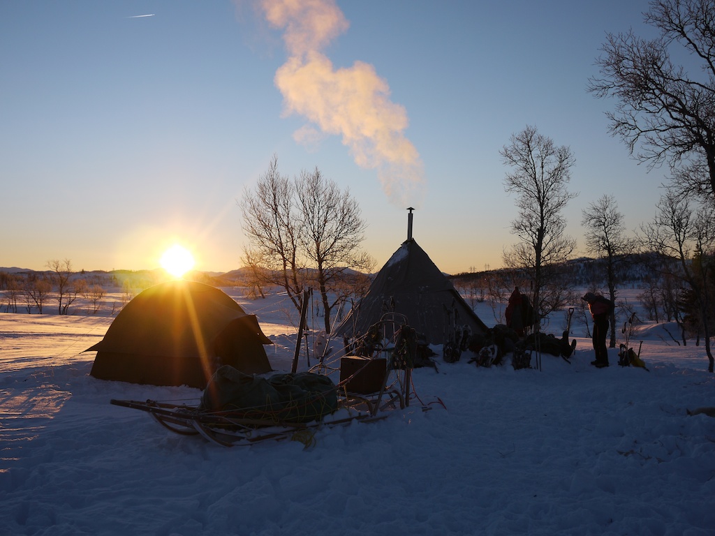
FRIDAY & SATURDAY - would be the culmination of our week with a 2 day trip involving a days snow shoeing to spend a night in the Lavu (wigwam like tent) before returning back to the hut the next day to the end of our wee.
 Leaving after a good breakfast we made our way over the lake where it was noticeably colder than previous days with the added wind chill. After crossing Møsvatn we made our way up and onto the plateau before heading down to over night camp.
 The evening was spent in the excellent company of Olav who introduced us to a 12month old trout delicacy & some tunes from his mandolin, all assisted by a drop of Whisky!!
 With some of us spending the night in a nearby tent and not the Lavu with its stove it was a little uncomfortable with an outside temperature of -30C! 
 Waking to frozen boots, frozen water bottles and lots of expletives(!) we all hungrily ate breakfast before packing up camp and setting off for our return journey back to the hut. Making our way via a different route than our journey to the Lavu we made the most of some stunning views on our last day. Again the temperature on the lake was bitingly cold in the cross wind!
Making our way to the lavu.
Stunning Norwegian scenery.
At the Lavu site with dogs being fed.
Olav entertains!
Sunrise over camp -30C!
Making our way over the flat surface of the frozen lake.

 "Have I got something on my lip?"


                                          Rob Johnson's video of the weeks expedition.


Norway Snow Shoe Expedition - 2013.
 All in all an 'excellent adventure' and a trip I would highly recommend!