About Me

My photo
Way back in time before the onset of adulthood I enjoyed countless days heading into the hills of Yorkshire with nothing more than a squashed sandwich & youthful sense for adventure! Despite long past youthful and work commitments keeping me in the city, the sense of adventure and love for the outdoors never left me. After digging my boots out and returning to the hills I attended a number of courses to improve my hill knowledge and skill base, during one of these courses it was suggested I join the Mountain Leader Training scheme and was delighted go on to gain the MOUNTAIN LEADER Award in April 2012. As well as spending time on the hills and mountains of the UK I have also enjoyed trips to the Nepalese Himalaya, Swiss & French Alps, Mallorca’s Tramuntana, Andorran & French Pyrenees, Morocco’s High Atlas, Tanzania’s Mt Meru & Kilimanjaro, Argentinian & Chilean Patagonia and winter expeditions to Norway’s Hardangervidda. Since gaining the ML I have also gained the SINGLE PITCH AWARD, INTERNATIONAL MOUNTAIN LEADER AWARD and the WINTER MOUNTAIN LEADER AWARD. I am now enjoying working in a freelance role whilst trying to get out climbing as much as possible.
Powered By Blogger

Sunday, 19 August 2012

Yorkshire Day Yorkshire 3 Peaks for the Yorkshire Air Ambulance.

 Ey up! As everybody knows August 1st each year is Yorkshire Day when Yorkshire folk celebrate all that makes 'God's Own County' great. This year I helped a group made up of staff from a number of Leeds bars display the famous Yorkshire folk's generosity by walking the route of the Yorkshire 3 Peaks to raise money for the Yorkshire Air Ambulance.

 The 'Charity Fundraising Deam Team' was (in alphabetical order of bar and no particular order of individual ability or level of suffering!)  - Johnny & Rosita (Distrikt)/ Alan (Lounge)/ Sam (Mojo)/ Kash (Sandinista)/ Si & Harry (Sandinista & Smokestack)/ Andy & Jeff (Wax Bar) & myself (Lounge/Sandinista/Sela/Smokestack & Wax!).

N.B  I am aware that the Yorkshire 3 Peaks was the subject of a previous Blog but thought as this is a description of a group challenge it was worth spending the (not insignificant due to my keyboard skills!) time relaying the story of the day to anyone interested.
Leaving Pen y ghent on the long walk to Whernside.
  Leaving Leeds at 06:00hrs we made the 45mile trip along the A65 to Horton In Ribblesdale to begin the route at 08:00hrs. We started the route eventually at 08:30hrs after the usual messing about getting ready and last minute toilet requirements!
 A typical Yorkshire summer day saw us enjoying low cloud, strong winds and a high chance of rain! We made our way along the road to Brackenbottom before making the turn to head up the incline towards Pen-y-ghent where after 5 to minutes a few faces started to look a bit concerned at what lay ahead! Making quite good time we made the summit point of Pen y ghent 1hr 15min after setting out where the strong Southerly wind assisted us display the White Rose flag!
On the shoulder of Pen y ghent.
"Ey up, 'appy Yorkshire Day tha nos!"


   Taking a detour from the conventional route we descended following the 'Pennine Way' towards Horton-In-Ribblesdale before taking the alternative '3 Peaks Challenge' route that is to be opened in 2013, this enabled us to miss the dreaded boggy section  where it has been known for things to get sucked off - usually just boots or trainers by the mud unfortunately!
 Low cloud hid the view across to Whernside which wasn't a bad thing as we were now a couple of hours in and walking thru the first consistently wet, muddy ground which found a couple of pairs of footwear less than waterproof and with most of the group being '3 Peaks virgins' in the realization of possibly another 9-10hrs to finish the route!!
Descending Pen y ghent on the Pennine Way (still enthusiastic!)
Kash measuring the distance by one smoke a mile!
Could of used a rubber dinghy over them rapids!


 Taking a 10minute lunch break at the road junction at 'Ribblehead Viaduct' allowed a couple of the group who had been enjoying a more leisurely pace(?) to stroll in to find most of the group having a bite to eat, whilst Si nearly pulled his hair out when failing to buy a cup of well earned tea as the guy in the tea van was over run with orders for 2 bacon sandwiches at the time - multi tasking hasn't yet reached the Yorkshire Dales!
 The long steadily rising route to the summit point of Whernside saw the group spread out as some of the team started to feel a few aches & pains in the old joints whilst others went thru troughs in energy levels.
   Up to this point we had been lucky escaping the heavy showers that had been forecast but could see dark clouds on the horizon!
Settle to Carlisle line with Ingleborough on the horizon.
Crossing the aqueduct on the steady long climb up to Whernside.
Approaching the half way point of the route on the way up Whernside
Dark clouds are gathering over Whernside!
2 down and 1 to go sheltering from the wind on Whernside.

 Leaving the summit along the 'whaleback' shaped Whernside until the path to 'Philpin Farm' and on towards 'Ingleborough' turned, we could see the heavy dark skies moving in. As we carefully made our way down the steeply descending, knee burning, rough stone steps the heavens opened soaking us to the skin within seconds and turned the path into a slippery mess.
 The rain continued to pour down which had a notable negative effect on team moral. On reaching the road that runs in the valley between Whernside & Ingleborough I decided to give a bit of a 'pep' talk and gave everyone the option of packing it in and calling a taxi to return to Horton In Ribblesdale, funnily enough everyone wanted to go on and complete the route. I'd like to think it was my moral boosting speech that inspired everyone to go on and nothing to do with the £40+ cost of a taxi or the potential persecution from the rest of the team for not completing the route!

 Those who had completed the route before knew full well what was in store as we made our way to Ingleborough and I received a few 'doubtful' looks when I described the route as a steadily rising path with a bit of a 'steep bit', I may of slightly understated the 'steep bit'!
 As we made our way towards what is nicknamed 'the Devils Staircase' the rain started to ease and the cloud lifted revealing the path in front of us, I thought I heard one or two profanities muttered though it could of been the wind?
Clouds still hide Ingleborough as Rosita models the full waterproofs look.
There's a 'bit of a hill' lurking in them clouds!
Kash decides to dance his way up?
  Taking a break at the foot of the 'Devils Staircase' to have some food and water we watched as Andy & Jeff headed up the steeply rising stairs alike 2 horny school boys trying to impress a girl on a school trip! The rest of us set off at more leisurely pace as the monsoon started to draw to a welcome close with the summit of Ingleborough and our final peak a very welcome sight.
Andy & Jeff head up the 'Devils Staircase'.
On ward and upward!
The rain has stopped but there is still a bit of a 'breeze' as Andy flies the White Rose.

  Now all that was left was the little matter of the 5.5mile walk back down to Horton In Ribblesdale to complete the circuit. This section is personally by far my least favorite due the fatigue on already aching limbs and sore feet, as well has having to pick your way carefully thru the slippery limestone section and muddy patches waiting to take your feet from under you.
 On the positive side the weather had definitely turned for the better with the cloud lifting sun breaking thru to give views across to Pen y ghent over the finish line!
Pen y ghent in the distance as the team cross the limestone pavement.
Sam & myself + blisters stride on.
A quick break in on the famous Yorkshire Limestone pavement.
Alan takes in the view across Ribblesdale to Pen y ghent.
Home stretch.
Kash, Alan & Sam make their way along the final mile.

  Back in Horton In Ribblesdale approx 11hrs after setting out it was a welcome change into dry clothes and foot wear and for some a much needed visit to the toilet facilities.
 We then decided a celebratory drink at the local pub was in order where we had a chat and a laugh about the day whilst the landlord seemed not comprehend the idea that to make money you need customers in as he sighed and stomped about whenever somebody approached the bar!
The 'dream team' full of smiles on completion of the 25mile charity fundraiser.
A very broken man!
 Up to date the group has managed to raise over £3000 for the Yorkshire Ambulance with more still to be added to this total. Despite the somewhat damp period of the afternoon everyone completed the route in good spirits and with good banter - same time next year.....?

                                                www.justgiving.com/YorkshireDay


Wednesday, 18 July 2012

Do Bears Sh*t In The Woods?

Do bears sh*t in the woods?
 Obviously the answer is yes, furthermore they 'go' not only in the woods but in the mountains, valleys and where ever they may roam.

 Like the bears, if you spend any length time in the outdoors weather it be for mountaineering, walking,camping, cycling, running etc its highly likely your going to need to answer the call of nature at some time!

 Unlike the bears roaming the wilderness, whilst we are following our chosen activity in the outdoors there is a good chance of us seeing another person or coming across evidence that other people have been around. In the UK especially there are very few area's in the great outdoors that are not chris-crossed by paths and tracks which are used to access the mountains, fells & remote area's - the last thing we want is to be stepping in other peoples business or drinking from contaminated streams and rivers. Gut pathogens such as E coli and Cryptosporidium can be picked up by drinking contaminated water.

 So what do we do? -
 For both N°1's & 2's ensure a minimum distance of 200ft/60m from any stream, river, 'boggy' area, track, path or wild camping site. The more distance the better especially from a wild camping site as your less likely to find a 'surprise' left by any one else!

 For N°2's there are a number of options to consider -
A) Take it home-
1, This would be the best option for the environment and easily done by placing your hand in a suitable plastic bag such as a baby's nappy bag and retrieving the N°2 before turning the bag back on itself. Then placing any toilet tissue in the bag also before tying the bag up then placing it in a further plastic bag or container to ensure against spillage.
B) Dig A Hole-
1, After finding a suitable site you should dig a hole 6-8inches down keeping the removed soil close to refill the hole.
2, After doing 'what you had to' refill the hole and place a stone on top to prevent any animal digging the 'business' up again.

 Toilet Tissue - takes a very long time to biodegrade so after 'answering natures call' there is a decision to made on how to dispose of the toilet tissue -
   a) burn the tissue with a lighter ensuring that there are no embers left alight.
   b) take the used tissue with you in an appropriate container or bag.
   c) use moss instead of toilet tissue, it is usually abundantly available in the outdoors and works perfectly well.
N.B Sanitary towels or tampons should be taken home in a polythene bag or nappy bag to avoid being dug up by animals.

Equipment To Be Carried -
a) A small garden trowel to dig a hole 6-8inches deep.
b) Toilet tissue for the obvious or use moss which saves carrying the toilet tissue and can be disposed of easily without concern.
c) Lighter to burn any used toilet tissue.
d) Baby's nappy bags to put any 'business' or toilet tissue in.
e) Further plastic bag or container to ensure against leakage from nappy bag.
f) Anti-bacterial hand cleanser.
Although there a few items this collection can be easily stored and carried in a rucksack.
Lighter, Nappy Bags, Toilet Tissue, Sealable Plastic Bag,Hand Cleanser,Trowel.

Enjoy the great outdoors but don't leave a mess!


Monday, 16 July 2012

The Yorkshire 3 Peaks - In Pieces!

 The route is a long, challenging but manageable and rewarding day that most people with a reasonable level of physical fitness, plus a helping of will power to overcome possibly sore feet & legs, will be able to complete.
 To complete 'The 3 Peaks Challenge' a finishing time of under 12 hours is needed though most people aim for around 10 hours.

“Some people have chosen to regard the walk as a race, and this is to be greatly regretted, walking is a pleasure to be enjoyed in comfort” - Alfred Wainwright
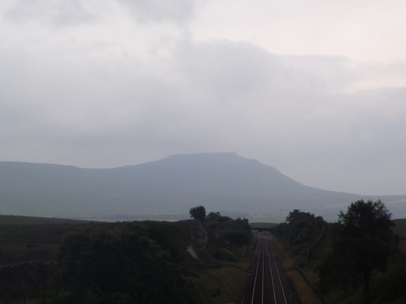
The flat summit Ingleborough in the distance.
 The 24mile/38km route of the Yorkshire 3 Peaks lies within the Yorkshire Dales National Park and takes in the 3 peaks of Pen-y-ghent (694 m/2,277 ft), Whernside (736 m/2,415 ft) & Ingleborough (723 m/2,372 ft). It is important (and a relief!) to note that the total height of these peaks is not the height needed to be climbed, the peaks are measured from sea level and as we start above sea level the actual height ascended is approx 1,600m/5,249ft.

 The route is usually followed in an anti clockwise direction heading out from 'Horton-In-Ribblesdale' and ascending 'Pen-y-ghent' first.
 When explaining the route to others I have often found it easier for them to understand when broken down into easily identifiable sections and so i will do here too -

Horton-In-Ribblsdale over Pen-y-ghent - Leaving 'Horton-In-Ribblesdale' from the 'Pen-y-ghent' cafe the track passes through a gate before it splits to the left and right. Taking the turning to the right the track heads to thru a farm yard, over a small wooden bridge before joining the road to 'Brackenbottom'. Reaching the farm buildings at 'Brackenbottom' after approx 800m the route leaves the tarmac and the ascent begins! Through grazing pasture and some limestone formations the route makes it way to the junction with the 'Pennine Way' where it turns left and begins to rise steeply following stone steps to the summit.The total ascent to the 694m summit of Pen-y-ghent is 454m and a distance of just under 4km from 'Horton-In-Ribblesdale'
This section takes approx 1-1.5hr*
The road to 'Brackenbottom'

The track to Pen-y-ghent which a steep turn to the left in the distance.
The steep 'steps' section to the summit.

 Pen-y-ghent to Ribblehead Viaduct- Descending from the summit of 'Pen-y-ghent' the route heads  North West towards 'Whernside' and the, sometimes visible, 'Ribblehead Viaduct' approx 11.5km away. This section takes the route through 'Horton Moor' & 'Tober Moss' where there can be very wet conditions underfoot at the best of times which can be very tiring to wade through or pick your way around. With no ascents of note the route winds its way through moor then grazing land before passing over a foot bridge at 'Nether Lodge' and joining a well surfaced track that leads to 'Lodge Hall'. Shortly after passing through the 'Lodge Hall' buildings the track meets the B6479 and heads North West for approx 1.5mile on the tarmac to 'Ribblehead Viaduct'.
This section takes approx 2.5-3hrs depending on speed and fitness of those walking and the condition of the wet ground!
Some sections can be a 'little bit soft' in wet conditions!


Leaving Pen-y-ghent behind
  Ribblehead Viaduct to Whernside- Walking alongside the extremely impressive Victorian engineering of the 'Ribblehead Viaduct' the route follows the 'Settle-Carlisle' railway track until it crosses the aqueduct and starts to rise more steeply as it passes 'Force Gill'. The path to the summit of 'Whernside' crosses a stile on the left and is on a good surface with slabs of stone laid in sections to prevent soil erosion. The route continues to rise steadily before it then makes its way alongside the stone wall that runs along the 'whaleback' shape of 'Whernside', which standing at 736m above sea level is the highest point in 'Yorkshire'. The summit point is some 441m above and 6.5km from the section starting point.
This section takes 1.5-2hrs*
Ribblehead Viaduct below Whernside.
The route to the right of Ribblehead Viaduct.


Whernside to Low Sleights Road - From the summit of 'Whernside' the route follows the 'whaleback' for approx 1.2km before taking a turn to the left and down steeply. This is where the knees start to feel the stress of the 20km already done and the strain of stepping down over a large stones formed into a rocky stair case. The path drops quickly until it reaches 'Bruntscar' where it again becomes tarmac and passes through pasture on either side reaching 'Philpin Farm' where there may be an opportunity to purchase a snack or drink and take a toilet break at weekends. Another 300m sees the route turn left onto 'Low Sleights Road' and a total distance of 4.5km from the summit of 'Whernside'.
This section takes approx 1.5hr*
From Whernside to Ingleborough (on a clear day!)
Whernside towards the Howgill Fells.
Low Sleights Road to Ingleborough - Turning right through the gate after 'The Old Hill Inn' the route leaves the last of the tarmac behind until the finishing point in 'Horton-In-Ribblesdale' and heads South winding its way through the limestone pavements which were scraped clean during the last ice age. The route rises gradually then passes through a gate where the track is now paved with large slabs of stone as on the ascent of 'Whernside', the slabs take you across a couple of streams and through 'Humphrey Bottom'. After approx 2.8km of gradually gaining height the route leads to what is known locally as 'The Devils Staircase', a rise of 100m over a distance of just 220m on a stone staircase.A the name implies the staircase it can be a bit of a devil on the now tired knees and legs!
 After reaching the top of the 'Devils Stair Case' there is chance for a quick deep breath in before the route leads up a further 100m over a distance of 650m and arrival at the summit, a total of 3.7km ascending 406m.
This section takes approx 2-2.5hrs*
The 'Devils Stair Case'
A lonesome figure makes his way up the final few steps of the 'Devils Stair Case'.
Ingleborough to Horton-In-Ribblesdale- The final section of the route leaves from the North Eastern point of the flat summit of Ingleborough, from this point, and with good weather, the track can be seen making its way down to 'Horton-In-Ribbledale' with 'Pen-y-ghent' in the distance. It is a long section at some 7.5km whilst descending 390m in height. As it leaves the flat summit the track again puts the tired knees to the test before descending more gently to make its way on a good surface which is boarded in some parts. The route passes through some sections of limestone which can be slippery in wet weather before entering some fields of pasture and finally crossing the railway lines and entering the village of 'Horton-In-Ribblesdale' and the finish!!!
This section takes approx 1.5-2hrs.
On the flat summit of Ingleborough.
The track makes its way to 'Horton-In-Ribblesdale' with 'Pen-y-ghent' in the distance.
On towards the limestone section.
 Refreshments & Toilets- After leaving the village at 'Horton-In-Ribblesdale' chances for refreshment and to use a flushing toilet are limited! There is sometimes a tea van parked at the road junction prior to following the route next to 'Ribblehead Viaduct', it is usually there at weekends and week days when there is decent weather.
 There is also a pub,'The Station', at the 'Ribblehead Viaduct' which serves good food, drinks and snacks when open.
 On weekends from May to September the 'Philpin Farm' operates a tea van in one of their barns serving tea, coffee, cold drinks & snacks & toilets.
 A further 300m on from 'Philpin Farm' is the 'Old Hill Inn' pub though as yet I've never been in here as I don't think I'd get started again so can't tell you very much about it!

Enjoy!!

*walking at an average speed of 3-4km/hr.


Friday, 6 July 2012

The National 3 Peaks - Part II (Doing!)

  After discussions with the group the event was to take place over the dates of Sunday 1st & Monday 2nd July. I chose this date for a number of reasons -
  1, it was approaching a full moon which may provide some light if given clear skies.
  2, it was the nearest full moon to the summer solstice when the days are longest.
  3, the event would start on a Sunday as both the mountains and the roads around them would be less busy with traffic and other groups undertaking the challenge.

  At 09:30am on Sunday 1st July Ellie, Chrissy, Jodie & Richard along with drivers Chris & Malc picked me up near Leeds in a mini bus packed with boots, clothes, waterproofs, back packs, food and water and we set off to West Highlands and our first mountain Ben Nevis.
  N.B It should be noted that the 'National 3 Peaks' involves a lot of driving between the mountains with a journey of 6hrs+ from Ben Nevis to Scafell Pike and a journey of 5hrs+ onward to Snowdon. Add to this the journeys to the start and from the finish its no small undertaking and could be dangerous to try walk the route and drive between mountains.

  During the 7hr journey I took the opportunity to give a safety briefing which outlined the procedure if there was a need to contact Mountain Rescue and what information should they be provided with, I also showed them the Aid Kit and Emergency Shelter I carry.

 Ben Nevis -
 Arriving in 'Glen Nevis' around 16:30hrs we readied ourselves for the first mountain. Ben Nevis summit stands 1344m above sea level and the route we were taking from near the Glen Nevis Hotel had a starting height of just 18m above sea level - leaving a route that climbs 1326m in a distance of 6.3km.
On the way up the Mountain Track (also known as the Pony or Tourist Track)

Mountain Rescue are winched down to make their way to a rescue (not us!)
On the summit with the emergency shelter in the background.


  The route to the summit took us past the halfway 'Lochan Meall ant-Suidhe' (which isn't quite halfway but lifts the spirits of those who don't know!) and on the Zig-Zags where we looked in awe as Navy Sea King dropped winched down a Mountain Rescue team on their way to a rescue in one of the gulleys on the Northern face of the mountain.  As we left the Zig Zags we had to walk through patches of snow which still laid on the approach to the summit and onwards until the ruins of the former weather observatory appeared out of the mist.
  After a quick bite and a photo we turned to retrace our steps back down the mountain and returned back to the mini bus where it was then over to Chris and Malc to drive through the night to get us to 'Wasdale Head' where we would continue the challenge and walk 'Scafell Pike'.

Scafell Pike -
  Arriving in Wasdale around 04:45am in the pouring rain and mist we readied ourselves and donned the water proofs to walk to the summit of England's highest peak Scafell Pike at 978m. The route we took climbs a total of 918m over a distance of  4.35km following the course of Lingmell Gill.
The rain soaked, muddy track rising from Wasdale Head.

The path leading up the delightfully named 'Brown Tongue' and the constant rain is dampening our enthusiasm.
It's all getting a bit too much for Richard!!
Visibility drops to approx 20m as we make our way from 'Lingmell Col' to the rocky summit.
The wet summit of Scafell Pike.


   We set out from 'Wasdale Head' at approx 05:00am and headed towards the fast flowing 'Lingmell Gill' in the pouring rain with the promise of low cloud and mist as we gained height. Passing by 'Brown Tongue' we made our way up the stone steps towards 'Lingmell Col' through 'Hollow Stones' and so avoiding the very steep track that leads to the summit via 'Mickledore', progress was markedly slower than that on 'Ben Nevis' due to the slippery surfaces underfoot as well as the poor weather conditions, fatigue and the 'boil in the bag' effect of wearing full waterproofs!
   It was very pleasing to see everyone making a conscious effort to keep the group spirit up as this was always expected to be the lowest point of the challenge with it being the middle section, undertaken at a time usually spent in bed, after a rough few hours in the back of a mini bus and having walked the highest mountain in Britain just hours before.
  Again it was a fleeting pause on top taking only time enough for a photo before leaving the wet, windy, misty summit to make the return walk back to Wasdale Head, the mini bus & some very welcome dry clothes!!

Snowdon -
  Arriving at the 'Pen-y-pass' car park at around 16:00hrs, the rain having never ceased during the journey from 'Wasdale Head' (so I was informed!), we quickly set off along the 'Miners Track' which would see us gain 726m of height over a distance of 6.37km to our final summit.
The steadily rising 'Miners Track' hides its surprise until later!
Water cascades down the mountain side (Robin Hood Prince of Thieves wasn't filmed here!)
Ah! The steady rise is over as the track changes to a steep path leaving 'Glaslyn' behind.
That'll be the mist again then!
"Out of the mist they appeared..."
They've done it! The summit of Snowdon.

  Leaving the 'Pen-y-pass' car park we made our way along the steadily rising 'Miners Track' and it felt good to escape the confines of the mini bus (which was by now at bit of a mess full of wet clothes and empty drinks and food containers) to stretch the legs. As we followed the track over the causeway that divides 'Llyn-Llydaw' the rain began to fall harder and the winds increased and continued to do so as we made our way up to, and around 'Glaslyn'.
  After passing the disused mine works we left 'Glaslyn' behind and the group set off up into the mist which covered the now steeply rising path as streams of water poured down. Onward and upward (and upward!), whilst putting already very tired legs to the test, we made our way to the standing stone marking the point where the 'Miners Track' meets the 'Llanberis Path' which was a very welcome sight. A further 10mins or so and the Snowdon summit came into view.
  Congratulations, a photo and a quick bite to eat were followed by a safety briefing from myself (boo!), it was important that every body got back down safely and so needed to stay focused despite their fatigue and because of the poor weather conditions. The descent back to 'Pen-y-Pass' passed quickly with a sense of achievement and good banter, though some dubious jokes!

  Summary - in the first days of planning the event I made it clear that though it would be nice to complete the event with in 24hrs it was more important to complete the challenge safely and not put undue pressure on either the walkers or the drivers. As it was, it was the M6 on a Monday morning that put an end to any chance of completing within the 24hrs!
  I was delighted by the spirit shown by Ellie, Chrissy, Jodie & Richard through out the challenge especially when the weather was trying bring everyone's mood down.
 Very well done to all!!!


Wednesday, 4 July 2012

The National 3 Peaks - Part I (Training)

 In the Autumn of 2011 I was asked if I would be available to help a group complete the '3 Peaks' for charity by Ellie & Chrissy. It was only after I had agreed to offer my services, as they were raising monies for 'Help For Heroes' & 'Cancer Research', that they made it clear it was the 'National 3 Peaks' they were intending to do and not the 'Yorkshire 3 Peaks' as I had thought!
 As 2011 drew to a close I put the outline of how I would like the event to run together including - dates, training dates, kit lists, mountain profiles, potential dangers etc and presented to Ellie & Chrissy. I made it clear that at that point it was my intention to try put them off doing the event and they might want to look for something that may be easier and that carried a lesser chance of failure, I did this to ensure their commitment to the event as it was in no way going to be easy!! To their credit they were unperturbed by the physical, financial or time commitments a successful event would demand.

 Neither Ellie, Chrissy, Jodie or Richard had done much, if any hill/mountain walking in the past so it was decided I would take them on a couple of training routes to give them a small idea of what they could expect and also so both they, and I, could assess their fitness and kit and look for any potential problems. To enable the group to gain some 'mountain fitness' they would also meet regularly to get out in the Derbyshire Peak District which was most easily accessible to them and look to increase on their general fitness and stamina levels.
 N.B It is important to note that hill/mountain walking not only makes demands of the body's  cardiovascular fitness. Demands are also made of the body's skeletal and muscular systems including tendons and ligaments which may be put under greatly increased stresses to enable the body to make controlled movements over different terrains and surfaces of all angles whilst both ascending and descending the mountain.

 The first of our training routes was planned to take place on Sunday 29th April in the 'Yorkshire Dales National Park' to walk the 24.5mile route of the 'Yorkshire 3 Peaks' (Pen-y-ghent, Whernside & Ingleborough). During the week leading up to the walk I payed close attention to the weather forecast which was looking decidedly 'spicy' with possible temperatures around 2°C and winds in excess of 50mph. I kept the group updated and also made clear the potential risks of walking in those conditions, to their credit they were insistent they wanted to go ahead as it would be good experience as long I was happy to take them -

Mountain weather - Met Office Mountain Weather Forecast
The approach to Pen-y-ghent and it was getting 'breezy'!
Getting out of the wind and 'Baltic' temperatures on Pen-y-ghent.
One benefit of the freezing temperatures was the 'easier' going over the frozen notorious peat bog.

  We set off into Strong winds and made our way up to the summit of Pen-y-ghent where the wind speed increased and buffeting gusts threatened to knock us off our feet. As we continued the winds grew stronger and we were subjected to a pelting of tiny ice particles which found their way to bite at any exposed skin! After 4hrs we reached the base of Whernside where we took a quick food break.
  As we snacked a couple of experienced looking guys told us they had struggled to even stand up as they walked over Whernside due to the winds, I thought this information may have caused worry in the group but they were still keen to go on.
  Heading towards Whernside we walked past 'Ribblehead Viaduct' and to 'Force Gill' where, as we gained height it became necessary to pause and brace against the ever increasing gusts. It was at this point that I felt conditions were approaching the limits of where I thought it safe and would only further deteriorate as we went on, it was to the disappointment of the team that I decided to call an end to the route and that we should make our way back.
  It was a difficult decision to call a halt to the day as Ellie, Chrissy & Richard had traveled up the previous day and paid for accommodation and fuel etc, but safety of the group has to be the first consideration and it did give them an insight to possible conditions on the hills at any time of year.
  Great effort by all and a display of their commitment to the event.

  The second of our training routes saw Ellie, Chrissy & Jodie return to the 'Yorkshire Dales' on Sunday 26th May for what is one of my favorite training routes.
  The route begins at 'Ribblehead Viaduct' and heads back along Guber Road towards 'Horton-In-Ribblesdale' before taking a right turn towards 'Colt Park' and up the steep ascent of 'Park Fell'. The route then continues on to 'Ingleborough' then across to 'Whernside' before returning to 'Ribblehead Viaduct' - 2 of the 3 Peaks, 21km & 830m of ascent without the boggy bit!
Making their way up to Ingleborough summit
Ingleborough summit

Whernside in the distance
Enjoying the warm weather on Whernside
    It was a fine day with an air temperature approx 25°C + above that of the route we had done only a month before, the joys of living on an Island in a temperate climate! The steep ascent of 'Park Fell' soon got the heart pumping and lungs drawing in deep breaths. On the summit of Ingleborough, where we were rewarded with views of the 'Howgill Fells' to the North, the 'Lakeland Fells' to the North West & 'Morcambe Bay' shimmering to the East, we took a break for some food & water and to enjoys the views.
  We then headed back along the summit plateau and made our way down the notorious 'Devils Stair  Case' as people who were doing the 'Yorkshire 3 Peaks' came in the opposite direction, we were not at all envious of them going up the very steep stairs! Heading over towards 'Whernside' we took the chance of a refreshment/toilet stop at 'Philpin Farm' before heading up the ascent to 'Whernside' summit, here we passed literally hundreds of people making their way down from the summit with some of them looking very drained in the warm weather.
  Crossing the summit of 'Whernside' we then made our way down back to the starting point at 'Ribblehead Viaduct' passing the point at which I had drawn a halt to the previous training route in very different conditions. We completed in the route in a little of over 6hrs and I was very pleased with the ladies effort in preparing for the event proper - the remaining preparation was in their own hands!!!!